
File:Ireland (MODIS).jpg

預覽大小:436 × 600 像素。 其他解析度:174 × 240 像素 | 349 × 480 像素 | 558 × 768 像素 | 745 × 1,024 像素 | 1,600 × 2,200 像素。
原始檔案 (1,600 × 2,200 像素,檔案大小:2.69 MB,MIME 類型:image/jpeg)
摘要
| 描述 |
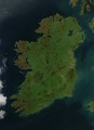
English: It is easy to see from this true-colour image why Ireland is called the Emerald Isle. Intense green vegetation, primarily grassland, covers most of the country except for the exposed rock on mountaintops. Ireland owes its greenness to moderate temperatures and moist air. The Atlantic Ocean, particularly the warm currents in the North Atlantic Drift, gives the country a more temperate climate than most others at the same latitude. |
| 日期 | |
| 來源 | NASA Earth Observatory |
| 作者 | Jeff Schmaltz |
| 其他版本 |
|
.jpg?uselang=zh-tw)
.jpg?uselang=zh-tw)
.jpg?action=history&uselang=zh-tw)
.jpg)
The cloud-free view shown here is extremely rare. The Moderate Resolution Imaging Spectroradiometer (MODIS) on NASA’s Aqua satellite captured the image on October 11, 2010, a time of year when Irish weather alternates between rainstorms from the west and cool, dry weather brought by high pressure systems known as anticyclones.
授權條款
| 本作品由NASA創作,屬於公有領域。根據NASA的版權政策:“NASA的創作除非另有聲明否則不受版權保護。”(參見:Template:PD-USGov/zh,NASA版權政策或JPL圖像使用政策) | ||
 |
警告:
|
檔案歷史
點選日期/時間以檢視該時間的檔案版本。
| 日期/時間 | 縮圖 | 尺寸 | 使用者 | 備註 | |
|---|---|---|---|---|---|
| 目前 | 2017年8月4日 (五) 12:14 | | 1,600 × 2,200(2.69 MB) | Blight55 | quality degraded from original, taken from original |
| 2017年4月21日 (五) 10:04 |  | 1,600 × 2,200(1.16 MB) | Blight55 | No borders in space, removed clouds | |
| 2011年12月25日 (日) 20:18 |  | 1,600 × 2,200(532 KB) | Tóraí | Less sever colour adjustments from original. | |
| 2011年12月13日 (二) 13:41 |  | 1,512 × 1,928(800 KB) | Soerfm | Brightness, crop | |
| 2011年3月17日 (四) 10:22 |  | 1,600 × 2,200(409 KB) | Originalwana | {{Information |Description ={{en|1=It is easy to see from this true-colour image why Ireland is called the Emerald Isle. Intense green vegetation, primarily grassland, covers most of the country except for the exposed rock on mountaintops. Ireland |
檔案用途
下列3個頁面有用到此檔案:
全域檔案使用狀況
以下其他 wiki 使用了這個檔案:
- af.wikipedia.org 的使用狀況
- ar.wikipedia.org 的使用狀況
- arz.wikipedia.org 的使用狀況
- ast.wikipedia.org 的使用狀況
- az.wikipedia.org 的使用狀況
- be-tarask.wikipedia.org 的使用狀況
- br.wikipedia.org 的使用狀況
- ca.wikipedia.org 的使用狀況
- ceb.wikipedia.org 的使用狀況
- cy.wikipedia.org 的使用狀況
- da.wikipedia.org 的使用狀況
- de.wikipedia.org 的使用狀況
- el.wikipedia.org 的使用狀況
- en.wikipedia.org 的使用狀況
- Ireland
- Geography of Ireland
- Gaelic Athletic Association
- Irish Rugby Football Union
- Swim Ireland
- Sport in Ireland
- United Ireland
- Rugby League Ireland
- Irish Real Tennis Association
- Irish Sailing Association
- Hurlingham Polo Association
- List of fractals by Hausdorff dimension
- Cricket Ireland
- Australian Rules Football League of Ireland
- Baseball in Ireland
- Irish Ice Hockey Association
- Baseball Ireland
- Fencing Ireland
- Olympic Federation of Ireland
- Ladies' Gaelic Football Association
- Softball in Ireland
- Pitch and Putt Union of Ireland
- Cycling Ireland
- Horse Sport Ireland
- Basketball Ireland
- Tennis Ireland
- Boxing Union of Ireland
- Parachute Association of Ireland
- Football Association of Ireland
- Hockey Ireland
檢視此檔案的更多全域使用狀況。
.jpg)
.jpg)