
File:Istočna Slavonija, Baranja i Zapadni Srem-en.png

預覽大小:411 × 599 像素。 其他解析度:164 × 240 像素 | 329 × 480 像素 | 881 × 1,285 像素。
原始檔案 (881 × 1,285 像素,檔案大小:92 KB,MIME 類型:image/png)
摘要
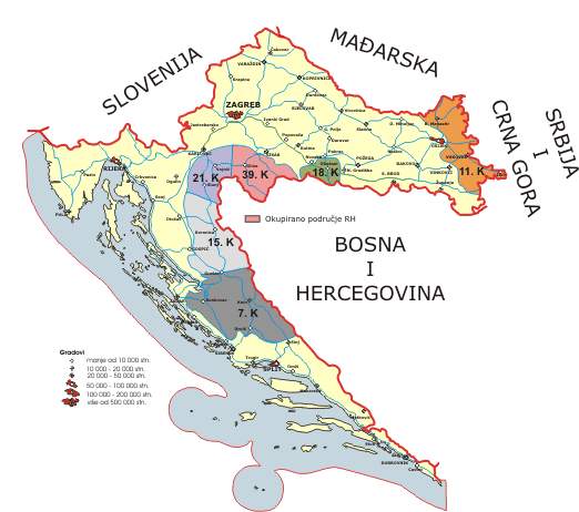
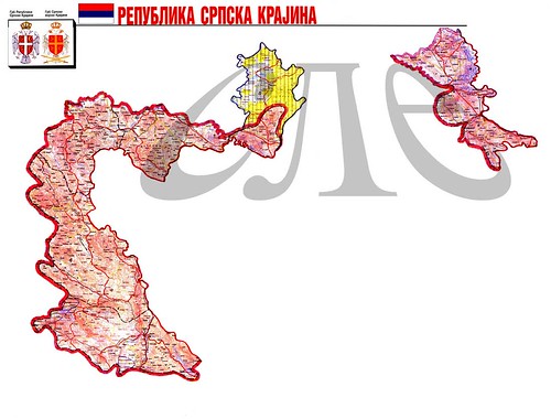
- English: Map of the Eastern Slavonia, Baranja and Western Syrmia, which was Serbian Autonomous Oblast (1991), part of the Republic of Serbian Krajina (1991-1995), self-governing entity (1995-1996), and UN-administered territory (1996-1998). Borders presented in this map are from 1994.
- Srpskohrvatski: Mapa područja Istočne Slavonije, Baranje i Zapadnog Srema, koje je bilo Srpska autonomna oblast (1991), deo Republike Srpske Krajine (1991-1995), samoupravni entitet (1995-1996) i teritorija pod upravom UN-a (1996-1998). Granice predstavljene na ovoj mapi su iz 1994. godine.
Source and licence
Map was created by en:user:PANONIAN and was originally uploaded into English Wikipedia. It was moved to Wikimedia Commons by User:Amadalvarez. User:Amadalvarez is not author of this map.
| 我,此作品的版權所有人,釋出此作品至公共領域。此授權條款在全世界均適用。 這可能在某些國家不合法,如果是的話: 我授予任何人有權利使用此作品於任何用途,除受法律約束外,不受任何限制。 |
References
- Sve srpske mape - od šestog veka do Pariza, Specijalno izdanje BLICA, Decembar 1995. godine.
- Dr Tomislav Bogavac, Nestajanje Srba, Niš, 1994.
- Miodrag Milošević, Geografija za 8. razred osnovne škole, Beograd, 1994.
- Dragan Rodić, Geografija za I ili III razred srednje škole, Beograd, 1995.
- Istorijski atlas, Geokarta, Beograd, 1999.
- Richard Overy, The Times History of the 20th Century, Times Books, London, 2004.
- The Times History of Europe, Times Books, London, 2002.
- Slavko Vejinović, Srbi u dijaspori u prošlosti i sadašnjosti, Novi Sad, 1999.
- Tim Džuda, Srbi - istorija, mit i razaranje Jugoslavije, Beograd, 2003.
- Džon R. Lempi, Jugoslavija kao istorija, Beograd, 2004.
- Nada Miletić Stanić, Pravoslavne crkve u Baranji, Novi Sad, 1999.
- http://web.ku.edu/~eceurope/hist557/lect20_files/yugoslavprovinces.jpg archive copy at the Wayback Machine
- http://terkepek.adatbank.transindex.ro/kepek/netre/292.gif
- http://www.pointernet.pds.hu/touristinfo/croatia/image/g.jpg archive copy at the Wayback Machine
- http://clip2net.com/clip/m6499/1217833413-krajina_army_territorial_division-jpg-34kb.jpg
- http://profile.ak.fbcdn.net/hprofile-ak-snc4/50514_294052851171_2302284_n.jpg archive copy at the Wayback Machine
- http://www.vecernji.hr/slika-500x329/vijesti/otkrivamo-britanci-trazili-da-baranju-dio-istocne-slavonije-predamo-srbiji-slika-85519[失效連結]
- http://www.srpskapolitika.com/krajina/mapa211.jpg archive copy at the Wayback Machine
- http://www.srpska-mreza.com/MAPS/Ethnic-groups/map-UN-1994.jpg
- http://www.srpskapolitika.com/krajina/etnicka_karta.jpg archive copy at the Wayback Machine
- http://www.srpskapolitika.com/krajina/mapa311.jpg archive copy at the Wayback Machine
- http://farm1.static.flickr.com/45/110412384_09ffb827cb.jpg
檔案歷史
點選日期/時間以檢視該時間的檔案版本。
| 日期/時間 | 縮圖 | 尺寸 | 用戶 | 備註 | |
|---|---|---|---|---|---|
| 目前 | 2011年6月1日 (三) 20:14 | | 881 × 1,285(92 KB) | PANONIAN | improved version with corrected borders |
| 2006年10月1日 (日) 05:27 |  | 754 × 1,116(235 KB) | Amadalvarez | map of the Eastern Slavonia, Baranja and Western Srem (self made) I'M NOT THE AUTHOR. It's been copied from english wiki, where it has GFDL self Licensing from his author, en:user:PANONIA {{PD-self}} [[Category:Yugoslavia [[Category:SVG maps o |
檔案用途
下列2個頁面有用到此檔案:
全域檔案使用狀況
以下其他 wiki 使用了這個檔案:
- ar.wikipedia.org 的使用狀況
- be.wikipedia.org 的使用狀況
- ca.wikipedia.org 的使用狀況
- de.wikipedia.org 的使用狀況
- en.wikipedia.org 的使用狀況
- es.wikipedia.org 的使用狀況
- fa.wikipedia.org 的使用狀況
- hu.wikipedia.org 的使用狀況
- it.wikipedia.org 的使用狀況
- ja.wikipedia.org 的使用狀況
- ko.wikipedia.org 的使用狀況
- mk.wikipedia.org 的使用狀況
- mzn.wikipedia.org 的使用狀況
- nl.wikipedia.org 的使用狀況
- no.wikipedia.org 的使用狀況
- pl.wikipedia.org 的使用狀況
- pt.wikipedia.org 的使用狀況
- ru.wikipedia.org 的使用狀況
- tg.wikipedia.org 的使用狀況
- tr.wikipedia.org 的使用狀況
- www.wikidata.org 的使用狀況