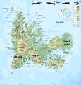
File:Kerguelen topographic map-fr.svg

页面内容不支持其他语言。
這個文件來自維基共享資源
维基百科,自由的百科全书

原始文件(SVG文件,尺寸为1,840 × 1,915像素,文件大小:2.33 MB)


摘要

描写
English: Topographic map of the Kerguelen Islands, Indian Ocean, France. Use the PNG version for inserting into articles as it is lighter.
Français : Carte topographique des îles Kerguelen. Utiliser la version PNG dans les articles pour un chargement plus rapide et un meilleur rendu.
  • UTM projection, WGS84 datum
  • The shaded relief is an embedded raster image, delete it to make the file smaller.
日期
来源

Own work. Sources of data:

Created using this tutorial by User:Sting.
創作作者
地理参考 地理参考Wikimaps Warper中的地图 如果不适当,请设置 warp_status = skip 为隐藏。
其他版本

此文件衍生的作品:  Kerguelen topographic map-bg.svg [编辑]

图像 of the year
图像 of the year
Featured 图像

维基共享资源

本文件是维基共享资源特色图片(Featured pictures),并被视为最好的图像之一。

如果你拥有相似质量的可采用适当著作权许可协议发布的图像,一定要上传标记推荐它。


翻譯此檔案 此SVG檔案包含可翻譯至您的語言的内嵌文字,可以使用任何可用SVG編輯器、文本編輯器或SVG翻譯工具來翻譯。詳情請見:關於翻譯SVG檔案

许可协议

English: This map has been created by Rémi Kaupp (User:Korrigan) and released under the license(s) stated below. You are free to use it for any purpose as long as you credit me and follow the terms of the license. You may need to credit the sources of data of the map (please check). Example:
Français : Cette carte a été créée par Rémi Kaupp (User:Korrigan) et placée sous la ou les licence(s) ci-dessous. Vous êtes libre de la réutiliser, tant que vous me citez en tant qu'auteur et suivez les instructions de la licence. Certaines sources de données de la carte doivent peut-être être créditées, veuillez vérifier. Exemple :
© Rémi Kaupp, CC-BY-SA, Wikimedia Commons
我,本作品著作权人,特此采用以下许可协议发表本作品:
GNU head 已授权您依据自由软件基金会发行的无固定段落及封面封底文字(Invariant Sections, Front-Cover Texts, and Back-Cover Texts)的GNU自由文件许可协议1.2版或任意后续版本的条款,复制、传播和/或修改本文件。该协议的副本请见“GNU Free Documentation License”。
w:zh:知识共享
署名 相同方式共享
This file is licensed under the Creative Commons Attribution-Share Alike Attribution-Share Alike 4.0 International, 3.0 Unported, 2.5 Generic, 2.0 Generic and 1.0 Generic license.
您可以自由地:
  • 共享 – 复制、发行并传播本作品
  • 修改 – 改编作品
惟须遵守下列条件:
  • 署名 – 您必须对作品进行署名,提供授权条款的链接,并说明是否对原始内容进行了更改。您可以用任何合理的方式来署名,但不得以任何方式表明许可人认可您或您的使用。
  • 相同方式共享 – 如果您再混合、转换或者基于本作品进行创作,您必须以与原先许可协议相同或相兼容的许可协议分发您贡献的作品。
您可以选择您需要的许可协议。

说明

添加一行文字以描述该文件所表现的内容
Topographic map of the Kerguelen Islands, Indian Ocean, France.

此文件中描述的项目

描繪內容

文件历史

点击某个日期/时间查看对应时刻的文件。

日期/时间缩⁠略⁠图大小用户备注
当前2010年4月25日 (日) 14:122010年4月25日 (日) 14:12版本的缩略图1,840 × 1,915(2.33 MB)KorriganCorrecting roads after advice from B.navez
2009年3月17日 (二) 21:022009年3月17日 (二) 21:02版本的缩略图1,840 × 1,915(2.33 MB)KorriganTypo ("prequ'île")
2009年3月17日 (二) 19:462009年3月17日 (二) 19:46版本的缩略图1,840 × 1,915(2.33 MB)Korrigan{{Information |Description={{en|Topographic map of the Kerguelen Islands, Indian Ocean, France. Use the PNG version for inserting into articles as it is lighter.}} {{fr|Carte topographique des îles Kerguelen. Ut

全域文件用途