
File:Bay Bridge collapse 2.jpg

此为最大尺寸。
Bay_Bridge_collapse_2.jpg (341 × 276像素,文件大小:12 KB,MIME类型:image/jpeg)
摘要
| 描述 |
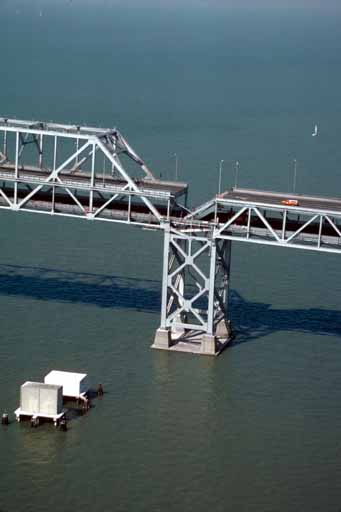
English: Aerial view of roadbed collapse near the interface of the cantil�T truss sections of the San Francisco-Oakland Bay Bridge. View northwestward. Cropped from original version to better fit en:San Francisco–Oakland Bay Bridge article. |
| 日期 | 摄于1989年10月 |
| 来源 |
USGS |
| 作者 | C.E. Meyer |
| 授权 (二次使用本文件) |
PD-USGov-Interior-USGS |
| 其他版本 |
|


许可协议
|
|
Wikipedia upload log
A Wikipedia description page is/was here. All following user names refer to en.wikipedia.
- 2007-09-04 19:13 Paul.h 341×276×8 (12116 bytes) [http://wrgis.wr.usgs.gov/dds/dds-29/ USGS photo] from 1989 Loma Prieta earthquake. '''Caption''': Aerial view of roadbed collapse near the interface of the cantil�T truss sections of the San Francisco-Oakland Bay Bridge. View northwestward. [C.E. Meyer
文件历史
点击某个日期/时间查看对应时刻的文件。
| 日期/时间 | 缩略图 | 大小 | 用户 | 备注 | |
|---|---|---|---|---|---|
| 当前 | 2008年7月6日 (日) 06:06 | | 341 × 276(12 KB) | Optigan13 | {{Information |Description={{en|Aerial view of roadbed collapse near the interface of the cantil�T truss sections of the San Francisco-Oakland Bay Bridge. View northwestward. Cropped from original version to better fit [[:en:San Francisco–Oakland Bay |
文件用途
以下页面使用本文件:
全域文件用途
以下其他wiki使用此文件:
- en.wikipedia.org上的用途
- he.wikipedia.org上的用途
- pl.wikipedia.org上的用途
- sl.wikipedia.org上的用途
- th.wikipedia.org上的用途
- tr.wikipedia.org上的用途