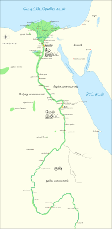
File:Ancient Egypt map-en.svg

此SVG文件的PNG预览的大小:293 × 598像素。 其他分辨率:117 × 240像素 | 235 × 480像素 | 376 × 768像素 | 501 × 1,024像素 | 1,003 × 2,048像素 | 1,577 × 3,219像素。
原始文件 (SVG文件,尺寸为1,577 × 3,219像素,文件大小:687 KB)
文件历史
点击某个日期/时间查看对应时刻的文件。
| 日期/时间 | 缩略图 | 大小 | 用户 | 备注 | |
|---|---|---|---|---|---|
| 当前 | 2023年10月20日 (五) 03:39 |  | 1,577 × 3,219(687 KB) | Haziq Faruqi | File uploaded using svgtranslate tool (https://svgtranslate.toolforge.org/). Added translation for ms. |
| 2022年3月17日 (四) 23:56 |  | 1,577 × 3,219(626 KB) | Manlleus | File uploaded using svgtranslate tool (https://svgtranslate.toolforge.org/). Added translation for ca. | |
| 2022年3月6日 (日) 15:23 |  | 1,577 × 3,219(564 KB) | Scratchinghead | File uploaded using svgtranslate tool (https://svgtranslate.toolforge.org/). Added translation for ta. | |
| 2022年2月25日 (五) 06:03 |  | 1,577 × 3,219(564 KB) | Scratchinghead | File uploaded using svgtranslate tool (https://svgtranslate.toolforge.org/). Added translation for ta. | |
| 2020年3月6日 (五) 19:29 |  | 1,577 × 3,219(501 KB) | Nilesh shukla | File uploaded using svgtranslate tool (https://tools.wmflabs.org/svgtranslate/). Added translation for hi. | |
| 2009年2月20日 (五) 11:28 |  | 1,577 × 3,219(413 KB) | Bibi Saint-Pol | fix translation mistake on the windrose | |
| 2009年1月30日 (五) 12:13 |  | 1,577 × 3,219(413 KB) | Bibi Saint-Pol | fix position of Nile Delta | |
| 2009年1月29日 (四) 12:21 |  | 1,577 × 3,219(412 KB) | Bibi Saint-Pol | remove wrong text, adjust frame | |
| 2009年1月29日 (四) 12:05 |  | 1,577 × 3,219(413 KB) | Bibi Saint-Pol | {{Assessments|1=Ancient Egypt map.svg|enwiki=1}} __NOTOC__ == {{int:filedesc}} == {{inkscape}} {{Information |Description= {{en|Map of Ancient Egypt, showing the Nile up to the fifth cataract, and major cities and sites of the Dynastic period (c. 3150 BC |
文件用途
以下2个页面使用本文件:
全域文件用途
以下其他wiki使用此文件:
- anp.wikipedia.org上的用途
- azb.wikipedia.org上的用途
- blk.wikipedia.org上的用途
- bn.wikipedia.org上的用途
- bs.wikipedia.org上的用途
- ca.wikipedia.org上的用途
- ceb.wikipedia.org上的用途
- ckb.wikipedia.org上的用途
- cs.wikipedia.org上的用途
- cv.wikipedia.org上的用途
- da.wikipedia.org上的用途
- en.wikipedia.org上的用途
- Ancient Egypt
- History of Africa
- Jean-François Champollion
- Old Kingdom of Egypt
- First Intermediate Period of Egypt
- 671 BC
- Wikipedia:WikiProject Former countries
- Cradle of civilization
- Portal:Africa
- Portal:Africa/Featured article
- Portal:Africa/Featured picture
- Portal:Ancient Egypt
- Portal:Ancient Egypt/Selected picture
- Portal talk:Africa/Featured picture
- Portal:Maps/Selected picture
- Thinite Confederacy
- Portal:Africa/Featured article/2
- Wikipedia:Featured pictures thumbs/09
- Wikipedia:Picture peer review/Ancient Egypt main map
- Wikipedia:Featured picture candidates/November-2007
- Wikipedia:Featured picture candidates/Ancient Egypt map-en.svg
- Wikipedia:Wikipedia Signpost/2007-12-03/Features and admins
- Portal:Africa/Featured picture/22
- Portal:Maps/Selected picture/32
- User talk:Jeff Dahl/Archive 2
- Portal:Ancient Egypt/Selected picture/2
- User talk:Jeff Dahl/Archive 3
- Wikipedia:Picture peer review/Archives/Jul-Dec 2007
查看本文件的更多全域用途。


